PingPath
PingPath is an AI-powered mobile application designed to enhance indoor navigation for visually impaired individuals. By leveraging LiDAR, …
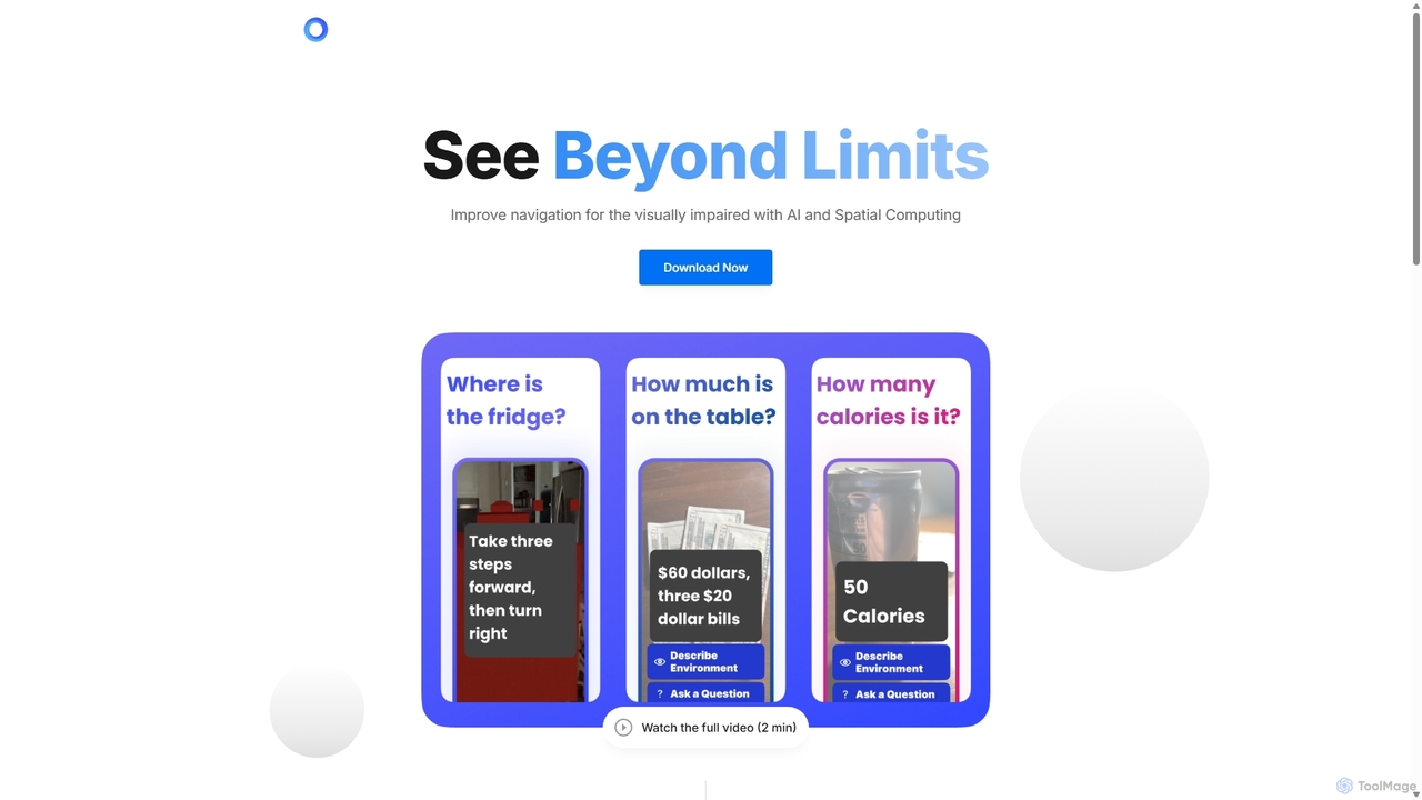
PingPath is an AI-powered mobile application designed to enhance indoor navigation for visually impaired individuals. By leveraging LiDAR, spatial computing, and intuitive spatial audio, it transforms a smartphone into a powerful assistive tool for identifying objects, avoiding obstacles, and confidently navigating unfamiliar indoor environments.
About Indoor Mapping
Indoor Mapping tools are AI-powered solutions designed to create, manage, and utilize detailed digital maps of indoor environments. As a specialized segment within navigation, these tools leverage advanced AI algorithms, sensor fusion, and spatial intelligence to provide precise positioning, navigation, and data visualization within complex buildings. They enable efficient space management, enhanced user experiences, and optimized operational workflows across various sectors.
Core Features
- Precise Indoor Positioning: Achieves highly accurate location tracking within buildings where GPS signals are unavailable or unreliable.
- 3D Spatial Modeling: Generates detailed three-dimensional representations of indoor layouts, including rooms, floors, and points of interest.
- Pathfinding & Navigation: Provides real-time, turn-by-turn directions for users or autonomous systems within mapped indoor spaces.
- Asset & Personnel Tracking: Monitors the location of equipment, inventory, or staff in large facilities for improved management and security.
- Spatial Analytics: Analyzes movement patterns, foot traffic, and space utilization to inform operational decisions and optimize layouts.
Use Cases
AI Indoor Mapping is crucial for environments requiring detailed spatial awareness and efficient movement. It is widely adopted in large public venues like airports and shopping malls for visitor guidance, in hospitals for patient and asset tracking, and in industrial facilities for optimizing logistics and safety protocols.
How to Choose
When selecting an AI Indoor Mapping tool, consider the required positioning accuracy, scalability for your facility size, ease of integration with existing systems, and the types of data analytics offered. Evaluate the complexity of map creation, update processes, and the level of support for various sensor technologies like Wi-Fi, Bluetooth, or UWB.
Indoor MappingUse Cases
Optimizing Facility Management in Large Campuses
Facility managers in universities or corporate campuses utilize AI Indoor Mapping to gain a comprehensive overview of building layouts, track maintenance equipment, and optimize cleaning or repair routes. This leads to more efficient resource allocation, reduced operational costs, and faster response times for issues across multiple buildings.
Enhancing Customer Navigation in Retail Malls
Shopping mall operators deploy indoor mapping solutions to provide visitors with intuitive, turn-by-turn navigation to stores, restrooms, or parking. This improves the customer experience, helps them discover new shops, and can be integrated with personalized promotions based on their real-time location within the mall.
Improving Patient & Asset Tracking in Hospitals
Healthcare providers leverage AI Indoor Mapping to track critical medical equipment like wheelchairs or infusion pumps, and to guide patients and visitors through complex hospital layouts. This reduces search times for assets, minimizes patient stress, and enhances overall operational efficiency in a dynamic environment.
Streamlining Operations at Airports & Transportation Hubs
Airport authorities use indoor mapping to assist passengers with navigation to gates, baggage claim, or amenities, and to monitor the movement of ground staff and equipment. This improves passenger flow, reduces delays, and enhances security and emergency response capabilities within vast terminal buildings.
Boosting Efficiency in Warehousing & Logistics
Logistics companies implement AI Indoor Mapping to create precise maps of warehouses, enabling optimized routing for autonomous guided vehicles (AGVs) and human pickers. This significantly reduces travel times, improves inventory accuracy, and accelerates order fulfillment processes, leading to substantial cost savings.
Guiding Emergency Responders in Complex Buildings
Emergency services utilize indoor mapping data to provide first responders with real-time, detailed layouts of buildings during critical incidents. This allows for faster navigation through unfamiliar structures, identification of safe routes, and precise location of individuals, greatly enhancing safety and effectiveness in emergencies.